Nearest Metro to Devanahalli
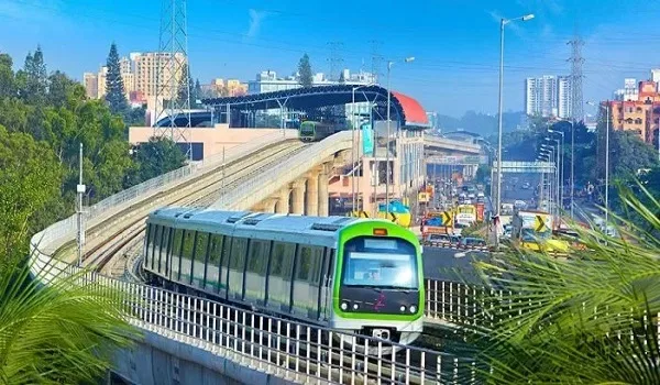
There is no operational metro station near Devanahalli today. Namma Metro does not reach this belt. The nearest working stations are far south, in the built-out city. Reaching one means a long drive down NH-44.
What Devanahalli does have is rail of another kind. Devanahalli railway station is on the Bengaluru to Hindupur line. It is a suburban and passenger stop, not a metro. Bus services on NH-44 carry far more of the load.
Metro will come. The Namma Metro Blue Line is under construction toward the airport. When it opens, the nearest station moves within a short drive. Until then, road is the honest answer.
Why No Metro Serves This Belt Yet
Namma Metro grew outward from the city core. Its operating lines end well short of the northern airport belt. Devanahalli is about 38 km from MG Road. That distance has always been outside the built network.
The Blue Line is the first corridor aimed this way. It runs Central Silk Board to KR Puram to the airport. Both phases are still under construction. Nothing on that line carries passengers yet.
So a Devanahalli resident wanting metro today must drive south. That is a long leg to reach a train. It is workable for an occasional trip. It is not a daily commute.
Devanahalli Railway Station: The Rail That Does Run
The Bengaluru to Hindupur line
Devanahalli station is on the broad-gauge line running north toward Hindupur. Passenger and suburban services stop here. The station is about 3 km from the Shettigere and Akalenahalli belt. It is easy to reach by road.
What it suits
The line works for trips toward Yelahanka, Yesvantpur and points north. Fares are low. It avoids highway traffic entirely. For the right journey, it is the fastest option available.
What it does not do
Service frequency is nothing like metro headways. Timetables govern, not turn-up-and-go. It does not serve the eastern tech belt. Treat it as useful rail, not a metro substitute.
People often confuse the two. A railway station on a map looks like transit access. It is transit access, of a limited kind. Check the timetable before you count on it.
Buses Along NH-44
BMTC services
BMTC runs city buses up the Bellary Road corridor. Airport services on this axis are the most frequent. They link the belt toward Hebbal, Yelahanka and the city. Stops on NH-44 are the common boarding points.
KSRTC and intercity routes
KSRTC uses NH-44 as a trunk route north. Buses toward Hindupur, Anantapur and Hyderabad pass through. That gives the belt intercity reach without entering the city. It is a real advantage of highway frontage.
Between them, the two operators cover most of what a metro would. The gap is reliability at peak hours. Buses share the road with everything else.
| Mode | Available today | What it covers |
| Namma Metro | No | Nothing in this belt yet |
| Suburban and passenger rail | Yes | Devanahalli station, Bengaluru to Hindupur line |
| BMTC city buses | Yes | NH-44 corridor toward Hebbal and the city |
| KSRTC intercity buses | Yes | Northbound trunk routes on NH-44 |
| Private vehicle on NH-44 | Yes | The default for most trips |
Read that table before believing any brochure map. Four of the five rows are real. The first one is not, and it is the one most often drawn.
Road Access, Which Is the Real Answer Today
The Devanahalli belt is close to things that matter, by road. Distances below are measured from the Shettigere side of the belt.
| Destination | Distance | Notes |
| Kempegowda International Airport | 5 km | About 10 minutes via NH-44 |
| Devanahalli railway station | 3 km | Bengaluru to Hindupur line |
| Devanahalli town centre | 2 km | Local shops, schools, government hospital |
| Doddaballapur Road junction | 8 km | Feeds the western industrial belt |
| Hebbal flyover | 28 km | Drive time varies sharply with traffic |
| MG Road | 38 km | The city core, and the long leg |
Read the shape of that list. Everything local is very close. Everything in the city is far. Metro would compress the second half, not the first.
What the Blue Line Will Change
The Blue Line runs Central Silk Board to KR Puram to the airport. It covers about 58.19 km across two phases. Phase 2A holds 13 stations. Phase 2B holds 17 and carries the airport leg.
| Item | Position today | After the line opens |
| Nearest metro station | Deep inside the city | Airport-area station, a short drive away |
| City interchange | None on this axis | KR Puram, onto the Purple Line |
| North Bengaluru offices | Road only | Hebbal stop on the same corridor |
| Local trips in the belt | Road | Still road |
Note the last row. Metro does not change short local movement. It changes the city leg. That is the whole of its value here.
Opening dates on this corridor have moved before. Nothing about them is settled. Read any published date as a projection.
How to Read Metro Claims in Marketing
Brochures in this belt often show metro lines as though they run. They do not. Ask one question of any seller. Is the station open, or is it planned?
A planned station is not worthless. It is simply a different thing. Price the property on road access, which is real. Treat rail as upside that may arrive late.
Projects here, including Milan at Godrej MSR City, are close to the airport by road. That is the fact that holds today. Metro is the layer that follows.
Metro alignments and timelines are set by BMRCL and change. Verify current status directly before any decision that rests on an opening date. Project approvals should be checked at rera.karnataka.gov.in.
Frequently Asked Questions
1. What is the nearest metro station to Devanahalli?
There is no operational Namma Metro station near Devanahalli. The working network ends well short of the northern belt. Reaching a station today means driving south along NH-44 into the city.
2. Is there any rail service in Devanahalli?
Yes. Devanahalli railway station is on the Bengaluru to Hindupur line and lies about 3 km from the Shettigere belt. It handles passenger and suburban services, not metro-style frequencies.
3. How do people travel from Devanahalli to the city now?
Mostly by road on NH-44 (Bellary Road). BMTC city buses and KSRTC intercity services both use the corridor. Private vehicles cover the rest.
4. When will metro reach Devanahalli?
The Blue Line's northern end is aimed at Kempegowda International Airport, not Devanahalli town. Construction is under way and projected dates have slipped before. Confirm the current position with BMRCL.
5. Will the Blue Line have a station in Devanahalli town?
The published alignment runs beside NH-44 through Yelahanka, Bettahalasur and Doddajala toward the airport. Residents of the belt would take a short road leg to an airport-area station, then metro onward.
6. How far is the airport from the Devanahalli belt?
About 5 km, roughly 10 minutes via NH-44 from the Shettigere side. That proximity is why the belt functions well on road access even without metro.
Explore Milan at Godrej MSR City